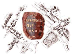
Among a collection of papers belonging to a friend, I was always drawn to one in particular, an enormous map of London upon which the city lay like some beached sea creature on sand, and not much less fragrant in its decaying case.
Though a relic of the first part of the last century, it has a resonance for the present age, depicting as it does a very recognisable London, with many of the landmarks familiar to the present day inhabitant. This familiarity survives the map's depiction of a much smaller city where the houses soon gave way to fields and open countryside: Earls Court was a hamlet, beside a ruin, and Islington had open fields on either hand.
London, though, was growing rapidly: ten years after the publication of the map, a railway station at Euston would throw open its gates to the traveller towards Birmingham: and, it hoped at that stage, to Bristol and even the Americas. The appearance of the Euston Arch proclaimed a new age, one which would drown Greenwood's map in a welter of change, though not before it had run to many editions and survived to be an exhibit in the Great Exhibition of 1851.
Knowing of the map's interest, it was tempting to bring about a happy collision between it and the world wide web. I 'storyboarded' a web site based on the map, and produced a sample, and on this basis set up the map's scanning. Unfortunately the resource had to be shoehorned into eighteen megabytes of disk space - it was showing tendencies towards sixty ...
An enquiry to an electronic mailing list (lis-maps) produced helpful replies from map professionals to a rank amateur, that led to an August train trip to a humid and thundery London to meet Ralph Hyde, an authority on the city, at the Guildhall Library, he kindly allowed me to add his notes on the map to the web resource. On the approach to the terminus the train passed a tethered pleasure balloon ascending from Vauxhall, which provided an unlooked-for link to the nineteenth century of Greenwood's map. Less familiar to Greenwood would be the modern city skyline, led by the then single eight hundred foot steel and glass tower, beside the West India Dock on the Isle of Dogs.
Hypertext markup language is a complicated name with a cumbersome acronym, for what was intended to be, and may still become, a simple little language for storing, sharing and displaying information in a way that one can find it again, the world over. A session (or five) in autumn evenings produced the set of files that allow navigation of the map in a reasonably sensible way: and a hiatus towards the end of the year allowed me to put the entire site through a couple of development cycles, making it easier on the eye, the user, and the infrastructure. The result hopefully provides a valuable resource for everyone who knows London.
© Mark Annand 18th October 2017. On the web February 1998 - August 2017. Please do not link to this map at its present location, which is temporary while we identify a permanent host for it. (If you can help, please get in touch.)
visitors since 14th February 2006. Counter by Statcounter.
